Priestess Of The Sun [continued]
Others have spoken of mystery megalithic stone arrangements and strange rock engravings that also existed in the surrounding bushland now lost forever. These sites were back in the hills, above the former waterline of the previous post ice-age lake, whose waters were part of the great waterways of the Sydney Basin, as described in Chapter Three.
The Burragorang waters extended into the eastern end of the Jamieson Valley and into the southern end of Cedar Valley, which lies on the western side of Ruined Castle, between there and Narrow Neck Peninsula. Waterfront settlements must have existed in these two valleys, and the Ruined Castle linked to them by ancient pathways now completely lost or barely visible in places. During fieldwork in the early 1970’s I found traces of what may have been an ancient wide pathway, which led from the eastern base of the ‘Castle’ along the northern base of Mt Solitary and down to the former water’s edge. This great lake would have covered the area now occupied by Jamieson Valley Farm.
Signs of ancient terraced crop growing occur in both these small valleys where bush foods were cultivated. However, it is the ancient ‘lost’ Uruan rock engravings of the Ruined Castle with which we are concerned.
The ‘Castle’ was mined for kerosene shale in the late 19th century, and a single gauge railway line extended to its base from the Katoomba Falls coal mine, the shale cars pulled by bullocks. The remains of some of the miners’ stone huts can still be found near the Ruined Castle’s base.
Today this natural formation is a pile of rubble collapsed into itself, but a narrow cleft allows access to the top for those willing to climb. The former Aboriginal tribespeople of the Burragorang region held the site sacred to the ‘culture-heroes’ who once lived there.
Upon a Narrow Neck cliff edge in November 1990 I found a strange inscription in Uruan glyphs reminiscent of symbols of the later Egyptian civilisation. There was an “All-Seeing Eye” symbol among others, and the Uruan hieroglyph for a pillar. A pointer symbol was aligned with Ruined Castle across the Jamieson Valley. The translation read:

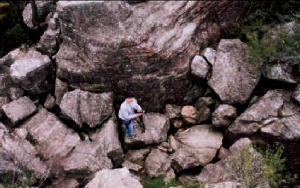
Rex Gilroy standing on the collapsed broken floor of the Nim Sun temple on the 'Castles' summit.
Photo copyright © Rex Gilroy 2004 |
‘To the south is the illuminating
pillar* whose rays heat.”
[*the ‘pillar’ is Ruined Castle]
A search of rocks around the Castle’s base later turned up a number of ancient ogham-type strokes and other symbols.
One lengthy inscription stated:
“This is a temple of sacrifice. Enter
in covered all men, for this rock
is the home of Nim’s radiance.”
Another ogham-type inscription states:
“It has been declared that Tu-ath
the bold, son of Hu the Elder, at
this temple has become its high
priest. This is declared by Hun”.
Another inscription stated that:
“People came by ship to observe
the Moon’s phases between the
stones for three time periods.”
Yet another inscription read:
“Da-i the Divine Queen came with
two ships to worship here offering bread.”
Here was the first mention of a Queen of Uru found in any Uru inscription. What territory, and from where, did Queen Da-i rule? Was she a monarch who ruled from somewhere in the Sydney Basin district, perhaps the ruler of a vast territory which covered the coastal lands far to the north and south of the Sydney district?
Another revealing inscription included symbols for a pillar, the moon, phallic and Earth-Mother glyphs and ships.
It stated:
“Three phases of the Moon have been
observed from this pillar.
The Sun-ship
brought the priestess Ianod for mating
with the divine Sun*.
She remained here
for Two Moons.”
[*More likely the High Priest took the Sun-God Nim’s role!]
Another impressive rock inscription stated:
“Out of the divine one, the exalted one,
have come rays. All people make offerings
to Him. The divine one has crossed the Sky.”
Atop the rise upon which the ‘Castle’ stands on another search I uncovered a short inscription in Uruan ogham-type glyphs:
“Assemble all here for prayer or petition.
The name of this temple is Ki*.”
[*Ki was an ancient Indo-Aryan word meaning “Life Force’ which it appears, had its beginnings in Australia.]
Another inscription found at the temple stated:
“Make an offering to the Sun-God of
ground meal*. The Solar disc is his image.”
[*No doubt the High Priest would have consumed the offering on behalf of Nim!]
Nothing more was found here until February 1996, when upon a cliffside I found the weathered outlines of a serpent, a cartouche, a human figure holding a serpent, a sun-disc and altar together with letterings which translated thus:
“To this place ships of the Sun-God
arrive. The Serpent-Priest at the altar
of I-a* makes sacrifice.”
[*I-a, the Uruan word for light.]
Another set of engravings appear to depict a priestess figure with accompanying female attendants in the act of praising the Sun disc with raised hands atop the long-since collapsed ‘Castle’.
There have since been found a number of other inscriptions in and around this great formation, to show that, several thousand years ago, at a time when it was in better condition, the Ruined Castle had been utilised as a megalithic sun-worship temple of the Uru, which rose above a settlement established at its base.
The inscriptions, all “Archaic Uruan” suggest the site was permanently occupied by a priestly caste at the head of which were a high priest and priestess, who officiated in ceremonies at the summit altar, sacrificial offerings being made daily when the sun was directly overhead. The Sun may have been ‘welcomed’ and ‘farewelled’ every dawn and dusk atop this natural monument.

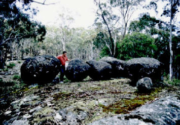
 Stone Arrangement


 Stone Circle
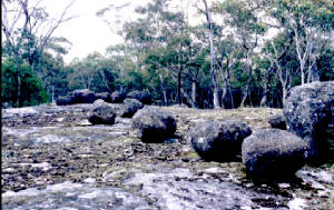
  Small Alignment
  Small Alignment

